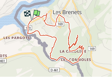
![](/images/other/stat-length.png)
![Tocht Andere activiteiten Le Locle - la tour deJurgensen des puis les Brenets (en Suisse) - Photo](https://media.geolcdn.com/t/1900/400/ext.pjpeg?maxdim=2&url=https%3A%2F%2Fstatic1.geolcdn.com%2Fsiteimages%2Fupload%2Ffiles%2F1545311037marcheuse_200dpi.jpg)
la tour deJurgensen des puis les Brenets (en Suisse)
margotte
Gebruiker
![Lengte](/images/other/stat-length.png)
![Max. hoogte](https://static1.geolcdn.com/siteimages/upload/files/1508320355ic_sort_altitude_max_24dp.png)
![Positief hoogteverschil](https://static1.geolcdn.com/siteimages/upload/files/1508320355ic_sort_den_pos_24dp.png)
![Km-Effort](/images/other/stat-length.png)
![Min. hoogte](https://static1.geolcdn.com/siteimages/upload/files/1508320355ic_sort_altitude_min_24dp.png)
![Negatief hoogteverschil](https://static1.geolcdn.com/siteimages/upload/files/1508320355ic_sort_den_neg_24dp.png)
![Boucle](https://static1.geolcdn.com/siteimages/upload/files/16400158638029165_repeat_loop_refresh_sync_direction_icon.png)
![Andere activiteiten](https://static1.geolcdn.com/sitytour/trail-icons/900.png)
3h07
Moeilijkheid : Gemakkelijk
![Scan deze QR-code om de tocht te openen in de SityTrail-applicatie](https://capi.geolives.com/qq0zvz2zws4bq2lad0pu/sitytour/trails/880836/qr.png?size=200)
Gratisgps-wandelapplicatie
Over ons
Tocht Andere activiteiten van 6 km beschikbaar op Neuchâtel, Onbekend, Le Locle. Deze tocht wordt voorgesteld door margotte.
Beschrijving
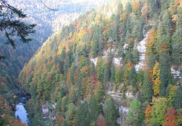
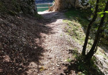
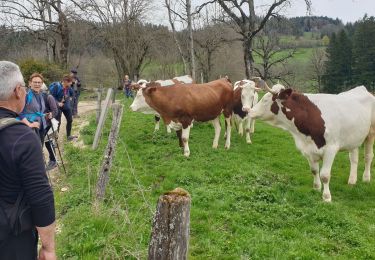
petite randonnée avec un joli point de vue sur les méandres du Doubs depuis la tour jurgensen. Retour par le col des roches qui s' ouvre sur une vallée étroite et humide où un parfun étrange se dégage avec comme compagnon des arbres doulletteent enveloppés dans leurs ganges de mousse.
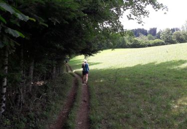
Plaatsbepaling
Opmerkingen
Wandeltochten in de omgeving
![Tocht Stappen Villers-le-Lac - Le saut du Doubs et le Châtelard - Photo](https://media.geolcdn.com/t/375/260/ext.jpg?maxdim=2&url=https%3A%2F%2Fservices.sitytrail.com%2FGeolivesWS%2FDownloadMedia.ashx%3FTrailID%3D792633%26Media%3Dfix__20170717135052.jpg)
![Stappen Stappen](https://static1.geolcdn.com/sitytour/trail-icons/101.png)
Stappen
![](/images/other/stat-length.png)
![](https://static1.geolcdn.com/siteimages/upload/files/16400158638029165_repeat_loop_refresh_sync_direction_icon.png)
![Tocht Te voet Le Locle - Hôtel du Saut du Doubs - Gare des Brenets - Photo](https://media.geolcdn.com/t/375/260/4e2b223b-5d1f-4722-b3d5-d37a87436a7c.jpeg&format=jpg&maxdim=2)
![Te voet Te voet](https://static1.geolcdn.com/sitytour/trail-icons/100.png)
Te voet
![](/images/other/stat-length.png)
![](https://static1.geolcdn.com/siteimages/upload/files/16400158638029165_repeat_loop_refresh_sync_direction_icon.png)
![Tocht Te voet Le Locle - Les Frêtes - fixme - Photo](https://media.geolcdn.com/t/375/260/0dfa81c4-ea86-4670-a9e2-4edd9205728f.jpeg&format=jpg&maxdim=2)
![Te voet Te voet](https://static1.geolcdn.com/sitytour/trail-icons/100.png)
Te voet
![](/images/other/stat-length.png)
![](https://static1.geolcdn.com/siteimages/upload/files/16400158638029165_repeat_loop_refresh_sync_direction_icon.png)
![Tocht Te voet Les Planchettes - Barrage du Châtelot - Saut du Doubs - Photo](https://media.geolcdn.com/t/375/260/c02ae770-bade-4d71-b842-d1ab9da9220c.jpeg&format=jpg&maxdim=2)
![Te voet Te voet](https://static1.geolcdn.com/sitytour/trail-icons/100.png)
Te voet
![](/images/other/stat-length.png)
![](https://static1.geolcdn.com/siteimages/upload/files/16400158638029165_repeat_loop_refresh_sync_direction_icon.png)
![Tocht Stappen Villers-le-Lac - 25 saut du Doubs jura 08.08.24 - Photo](https://media.geolcdn.com/t/375/260/69ae39c7-0bce-4ef7-9703-c0fe844c8fa9.jpg&format=jpg&maxdim=2)
![Stappen Stappen](https://static1.geolcdn.com/sitytour/trail-icons/101.png)
Stappen
![](/images/other/stat-length.png)
![](https://static1.geolcdn.com/siteimages/upload/files/16400158638029165_repeat_loop_refresh_sync_direction_icon.png)
![Tocht Stappen Villers-le-Lac - barrage chatelot saut du doubs le pissoux - Photo](https://media.geolcdn.com/t/375/260/9ddc7c9d-2c55-4135-9d10-7ad8ed129ab8.jpg&format=jpg&maxdim=2)
![Stappen Stappen](https://static1.geolcdn.com/sitytour/trail-icons/101.png)
Stappen
![](/images/other/stat-length.png)
![](https://static1.geolcdn.com/siteimages/upload/files/16400158638029165_repeat_loop_refresh_sync_direction_icon.png)
![Tocht Stappen Villers-le-Lac - Le Pisoux - Photo](https://media.geolcdn.com/t/375/260/4a715c23-f970-4542-83cb-bb9163df6e0f.jpg&format=jpg&maxdim=2)
![Stappen Stappen](https://static1.geolcdn.com/sitytour/trail-icons/101.png)
Stappen
![](/images/other/stat-length.png)
![](https://static1.geolcdn.com/siteimages/upload/files/16400158638029165_repeat_loop_refresh_sync_direction_icon.png)
![Tocht Stappen Villers-le-Lac - Saut du Doubs - Photo](https://media.geolcdn.com/t/375/260/5bf04ea4-00d2-4096-ab82-e6f5e7455237.jpg&format=jpg&maxdim=2)
![Stappen Stappen](https://static1.geolcdn.com/sitytour/trail-icons/101.png)
Stappen
![](/images/other/stat-length.png)
![](https://static1.geolcdn.com/siteimages/upload/files/16400158638029165_repeat_loop_refresh_sync_direction_icon.png)